
- UPSC LABS
- February 8, 2025
- 6:35 pm
- Ratings: ⭐⭐⭐⭐⭐
Geomorphology: Definition, Scope, and Importance in UPSC
Geomorphology is a fascinating and essential branch of physical geography that delves into the study of Earth’s landforms, their origins, evolution, and the processes that shape them. For UPSC aspirants, geomorphology is not just a subject to be studied but a lens through which the physical world can be understood. It provides the foundational knowledge required to comprehend the dynamic interplay between natural forces and the Earth’s surface. This article explores the definition, scope, and importance of geomorphology, particularly from the perspective of the UPSC examination.
Table of Contents
Definition and Core Concepts
Geomorphology is the scientific study of landforms and the processes that create and modify them. It is derived from three Greek words: geo (Earth), morph (form), and logos (study). At its core, geomorphology seeks to answer questions about how landscapes are formed, why they look the way they do, and how they change over time.
The discipline is built on two fundamental types of processes: endogenic and exogenic. Endogenic processes are driven by the Earth’s internal energy and include tectonic activities such as mountain building, volcanic eruptions, and earthquakes. These processes create the primary relief features of the Earth, such as mountains, plateaus, and ocean basins. For example, the Himalayas were formed due to the collision of the Indian and Eurasian tectonic plates, a classic example of endogenic activity.
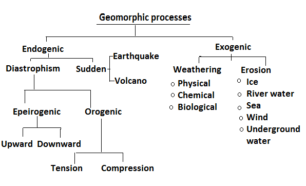
On the other hand, exogenic processes are driven by external forces such as wind, water, ice, and gravity. These processes include weathering, erosion, transportation, and deposition, which work to modify the landforms created by endogenic processes. For instance, the Ganges-Brahmaputra Delta, one of the largest river deltas in the world, is a result of exogenic processes where sediment carried by rivers is deposited at the mouth of the river.
Geomorphology also studies the concept of geomorphic cycles, which describe the stages through which landforms evolve over time. The most well-known theory in this regard is Davis’s cycle of erosion, which explains how landforms progress through stages of youth, maturity, and old age. Another important concept is plate tectonics, which provides the framework for understanding large-scale landform development, such as the formation of continents and ocean basins.
Scope of Geomorphology
The scope of geomorphology is vast and multidimensional, encompassing the study of landforms at various scales and their relationship with natural processes. It can be broadly divided into three main areas:
⦿ Structural Geomorphology: This branch focuses on the influence of Earth’s internal structure and rock types on landform development. For example, the Deccan Plateau in India is composed of basaltic rocks, which are resistant to erosion and give the plateau its characteristic flat-topped appearance. Structural geomorphology also examines fault lines, folds, and other geological features that shape the landscape.
⦿ Historical Geomorphology: This area studies the evolution of landforms over geological time scales. It involves reconstructing past landscapes and understanding how they have changed due to processes like erosion, sedimentation, and tectonic activity. For instance, the Thar Desert in Rajasthan is believed to have been a fertile region thousands of years ago, and its transformation into a desert is a subject of historical geomorphology.

⦿ Process Geomorphology: This branch focuses on the contemporary processes that shape landforms, such as fluvial (river), glacial, coastal, and aeolian (wind) processes. For example, the Brahmaputra River’s braided channels are a result of fluvial processes, while the sand dunes of the Thar Desert are shaped by wind action.
Geomorphology also categorizes landforms into first-order, second-order, and third-order features. First-order features include continents and ocean basins, second-order features encompass mountains and plains, and third-order features include smaller landforms like valleys, deltas, and sand dunes.
Historical and Theoretical Foundations
The study of geomorphology has evolved over centuries, with contributions from numerous scholars. William Morris Davis, often called the “father of American geography,” proposed the geomorphic cycle, which describes the stages of landform development. European geographers, on the other hand, emphasized climatic geomorphology, linking landforms to regional weather patterns.
Modern geomorphology incorporates advanced technologies such as Geographic Information Systems (GIS) and remote sensing to study landforms and processes in real-time. These tools have revolutionized the field, enabling precise measurements of erosion rates, sediment transport, and landform changes.
Importance in UPSC Preparation
For UPSC aspirants, geomorphology is a key subject under the Geography syllabus, especially in General Studies Paper I. The subject not only forms a major component of the Geography section in both the Preliminary and Mains exams but also has a broader application in understanding the physical landscape of India and the world.
Moreover, geomorphology connects with various other fields, such as disaster management, urban planning, and environmental policy, which are also covered in the UPSC exam. An understanding of human-environment interaction is crucial for tackling questions on sustainable development, natural resource management, and climate change. For instance, the study of coastal geomorphology is crucial for understanding the effects of sea-level rise due to global warming, while river dynamics are key to understanding flood management strategies.
Conclusion
For UPSC aspirants, geomorphology is not just a subject to be studied but a critical tool for understanding the physical world and its socio-environmental implications. It equips candidates with the knowledge to analyze geographical phenomena holistically, a skill that is essential for both the prelims and mains examinations. From understanding the formation of the Himalayas to addressing coastal erosion in Kerala, geomorphology provides the foundation for informed decision-making and sustainable governance. As the world faces unprecedented environmental challenges, the importance of geomorphology in shaping policies and strategies cannot be overstated.